Bidspirit auction | Edmond Halley - Map of
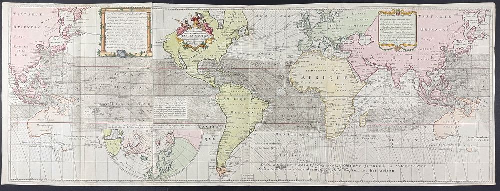
Edmond Halley - Map of the World (One of First Maps to indicate Isogonic Lines) - This stunning large folio map is Edmond Halley's Nova & accuratissima totius terrarum orbis Tabula Nautica variationum magneticarum index juxta observationes anno 1700 habitas constructa . It was published as part of Louis Renard's Atlas van Zeevaert en Koophandel door de Geheele Weereldt . This is from the first Dutch edition of the work published in Amsterdam by the Reinier and Josua Ottens in 1745. The map features beautiful hand-coloring (modernly-applied) on joined sheets. The map is presented on the Mercator projection, centered on America. Australia is shown both on the east and west of the map. Includes an inset of the Northern Polar regions. This is considered the Ottens issue of Halley's isogonic world chart first published in 1702 by Mount and Page. Edmund Halley (1656-1743) was an English astronomer and geophysicist and the second Royal Astronomer. He posited the theory of terrestrial magnetism to help explain variations in magnetism on the Earth's surface believing there existed four magnetic poles. He researched this theory between 1698 and 1700 captaining the Paramore across the Atlantic. This world chart was a result of his expedition. This and Halley's chart of the Atlantic were the first to indicate isogonic lines or Halleyan lines (lines that connected points of equal magnetic variation or compass declination). ”Thus the isoline, or lines of equal [magnetic] value, was invented. For more than a century Halley's magnetic lines were a familiar feature of the world chart.” (Shirley, p. xiv) Renard's sea atlas was developed predominantly from the plates of Frederik de Wit, who published his own maritime work circa 1675. Renard's atlas was first published in 1715 but became so useful and popular it was re-issued first in 1739 with more editions continuing until 1802. ”This continuous revision proves that the atlas was intended for use at sea and not only for the consultation on shore.” (Koeman) “This [atlas] was issued in three ways: uncoloured, the body of the map coloured and the cartouches left plain, and fully coloured.” (Tooley) The maps often feature exquisite cartouche work, likely drawn by Romeyn de Hooghe. The scenes in Renard's atlas would sometimes feature whaling, bear hunting, ivory trade, Indians, portrait of Magellan, costumes and animals of the respective regions, et al. Louis Renard (1678-1746) was a born in France to a Huguenot family. He worked as a book seller and publisher in Amsterdam, Netherlands from 1703. The Netherlands led the world in overseas commerce, engraving, and cartography with Renard as a masterful leader in the field. Paper Size: ~ 58” by 21 1/4” Paper Type or Special Features: Engraving with Professional Hand-coloring